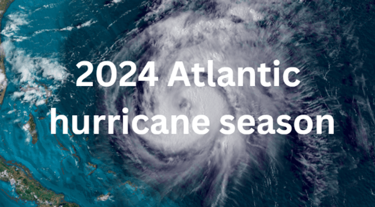
Guide to 2024 Atlantic Hurricane Season
The 2024 Atlantic hurricane season is upon us, bringing with it the potential for powerful storms that can impact coastal communities and beyond. This year's season, which officially runs from June 1 to November 30, is expected to be above average in terms of storm activity. Forecasters from NOAA’s Climate Prediction Center predict 17-24 named storms, with 8-13 potentially becoming hurricanes. Of these, 4-7 may develop into major hurricanes (Category 3 or higher on the Saffir-Simpson scale).
With these predictions in mind, early preparation is crucial. Now's the perfect time to start gathering supplies and making your emergency plans. A well-stocked emergency kit is your first line of defense against hurricane-related disruptions. Consider including items like non-perishable food, water, flashlights, and batteries.
Considering hurricanes often lead to extended power outages, which can leave you without essential electricity for days or even weeks. This is where a high-capacity backup battery becomes invaluable. This device can keep your phones charged, power medical equipment, run small appliances, and provide lighting when the grid goes down. Also it can keep your family's comfort and safety during the uncertain times that follow a hurricane.
When Is the 2024 Atlantic Hurricane Season
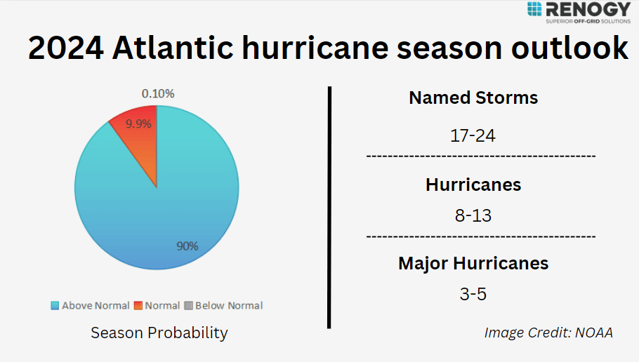
The 2024 Atlantic hurricane season officially begins on June 1 and ends on November 30 marking the period when tropical cyclones are most likely to form in the Atlantic basin. As we approach the 2024 hurricane season, the NOAA has released its initial forecast, indicating an above-average level of activity. According to their predictions, we can expect between 17 to 24 named storms with winds of 39 mph or higher. Of these, approximately 8 to 13 could intensify into hurricanes with winds of 74 mph or higher. Most concerningly, the forecast suggests that 3 to 5 of these hurricanes may become major, reaching Category 3, 4, or 5 status with winds of 111 mph or higher.
NOAA indicated that the atmospheric and oceanic conditions point to an above-normal Atlantic hurricane season in 2024, with a 90% likelihood. There's only a slim 10% chance of a near-normal season, and the possibility of a below-normal season is almost nonexistent. This prediction stems from several key factors:
- Ongoing El Niño conditions are expected to transition to neutral or potential La Niña conditions by summer, which typically favors increased hurricane activity.
- Sea surface temperatures in the tropical Atlantic and Caribbean are currently above average, providing more energy for potential storm development.
- The West African monsoon is forecasted to be stronger than usual, which can lead to more robust tropical waves moving off the African coast.
2024 Atlantic Hurricane Season Data & Resource
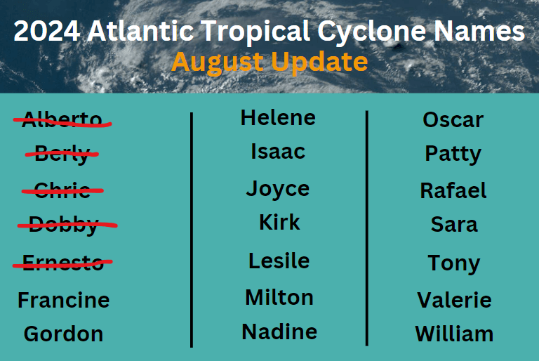
Tropical Storm Alberto was the first named storm of the 2024 Atlantic hurricane season, forming on June 19 and impacting areas of Mexico, Texas, and Louisiana. Alberto's storm surge resulted in one fatality. On July 1, Hurricane Beryl became the earliest Category 5 hurricane ever recorded in the Atlantic, bringing severe flooding to Texas and claiming 22 lives. The latest news, on August 13, Tropical Storm Ernesto hit the Caribbean. By August 14, it had strengthened into a Category 1 hurricane over northern Puerto Rico, causing power outages. On August 17, it struck Bermuda, and the official warned that the east coast of Florida faced dangerous rip currents. The next day, the storm and rip currents claimed three lives.
The picture below shows the names of the storms for the 2024 season, with Alberto, Beryl, Chris, Debby and Ernesto already having formed.
For the 2024 Atlantic hurricane season, NOAA plans several improvements to help predictions and preparations. These include enhanced communications with expanded Spanish-language products and experimental graphics, new forecasting tools like MOM6 and SDCON. NOAA will upgrade the systems that help understand and forecast hurricanes, such as improved coastal weather buoys and new observation technologies. Here can know more details about the measures taken by NOAA.
Understanding Hurricane Categories
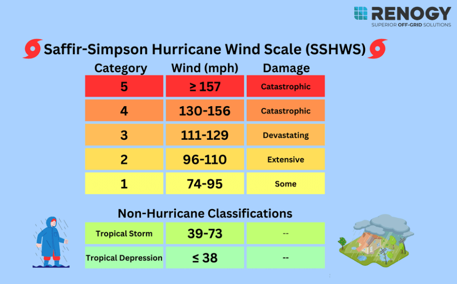
The Saffir-Simpson Hurricane Wind Scale classifies hurricanes into five categories based on sustained wind speeds, each category representing different levels of potential damage.
Category 1: Winds 74-95 mph (119-153 km/h)
Category 1 hurricanes can cause relatively minor damage, but they're still dangerous. Roof shingles, gutters, and siding on well-built homes can be damaged, trees with shallow roots may be uprooted, and widespread power outages will potentially last a few days. Low-lying coastal areas may experience flooding, though it's usually less severe than in higher categories.
Category 2: Winds 96-110 mph(154-177 km/h)
In areas hit by a Category 2 hurricane, widespread power outages become more common and tend to last longer. The damage to roofs and siding is more severe, with roads blocked by fallen trees and power lines. Coastal regions can experience moderate to severe flooding, and the destruction to piers and boats is significantly greater than what you’d see with a Category 1 storm.
Category 3: Winds 111-129 mph(178-208 km/h)
Category 3 hurricanes are considered major hurricanes, and they can cause significant damage to both well-constructed homes and older buildings. Water systems may be contaminated or damaged and water supply issues appear. Coastal flooding from storm surges can be severe, inundating homes, roads, and infrastructure. Storm surges in excess of 9 feet can flood large areas, especially along coastlines.
Category 4: Winds 130-156 mph(209-251 km/h)
A Category 4 hurricane brings catastrophic damage. Roofs and walls potentially being ripped off. Mobile homes and small buildings are often completely destroyed. Power and utility loss, power emergency and water shortages can last months. The storm surge can be devastating, with water levels rising up to 13 feet or more, flooding coastal areas and potentially moving far inland. Flash flooding from heavy rainfall can also occur in areas far from the coast.
Category 5: Winds 157 mph or higher(252 km/h or more)
Category 5 hurricanes are the most catastrophic storms, capable of destroying almost everything in their path. Homes and buildings are often flattened, infrastructure like road and communications collapse thoroughly, leading to isolation for affected communities. In some cases, entire regions may become uninhabitable for weeks or months due to the level of devastation, as seen in storms like Hurricane Dorian and Hurricane Maria.
Hurricane Damage
Hurricanes bring strong winds, heavy rainfall, and storm surges, causing different levels of damage depending on their intensity and size. After a hurricane, the destruction can severely disrupt daily life, leaving people without access to clean water, electricity, and essential supplies for days or even weeks. Understanding these potential impacts helps you prepare more effectively and make informed decisions about how to respond.
Strom Surge
Storm surge is one of the most dangerous effects of a hurricane. As the storm approaches the coast, its powerful winds can push a massive wall of water onto land, raising sea levels by 20 to 30 feet. This surge can wreak havoc on coastal areas, wiping out docks, roads, and homes, and causing severe beach erosion. Although storm surges typically last only a few hours, the destruction they cause in that short time can be immense.
Strong Winds
Strong winds are driven by the hurricane's rotating structure and pressure differences. These winds can cause significant damage, tearing apart buildings, uprooting trees, and creating hazardous flying debris. As a result, they often lead to widespread power outages, property destruction, and even serious injuries or fatalities.
Heavy Rainfall
Heavy rainfall is caused by the hurricane's ability to draw moisture from warm ocean waters. The resulting torrential rains can cause inland flooding, overwhelming drainage systems and natural waterways. This can damage property, disrupt transportation, and in severe cases, trigger landslides.
Flooding
Flooding, stemming from both storm surge and heavy rainfall, can inundate large areas. This often results in extensive property damage, displacement of residents, contamination of water supplies, and long-term economic impacts on affected communities.
Tornadoes
Tornadoes can form within the hurricane's rain bands due to wind shear and instability. While usually smaller than typical tornadoes, they can still cause significant localized damage to structures and pose a threat to life safety.
Rip Currents
Hurricanes can create dangerous rip currents in coastal waters, which are powerful, fast-moving currents that pull water away from the shore. These currents can be present before, during, and after the storm, posing a serious threat to swimmers by pulling even the strongest swimmers out to sea.
landslides
In areas with steep terrain, the heavy rainfall associated with hurricanes can saturate soil and trigger landslides or mudslides. These can be particularly dangerous in mountainous regions or areas with unstable geology.
How to Prepare for A Hurricane
A hurricane can cause widespread devastation during and after it occurs. you need to properly prepare for a hurricane and know how to protect yourself during and after one which makes a big difference in safety and resiliency in the wake of a hurricane.
Before a hurricane:Prepare
Get emergency notifications: Sign up for emergency alerts and notifications that your community may offer. You can receive alerts and warnings directly from the National Weather Service for all hazards with a NOAA Weather Radio (NWR).
Prepare a hurricane checklist: Get your emergency kit ready ahead of time. Stock it with essentials like bottled water, non-perishable food, a first aid kit, spare clothes, and basic supplies. Keep an eye on official alerts and the hurricane's progress, and be prepared to add or swap out items in your kit as needed.
Plan to evacuate: Get the lowdown on your community's evacuation plan and what the shelters are like. Plan your escape routes well before a hurricane hits. Double-check your potential evacuation routes to make sure they won't be blocked. Talk with your family about where you'll meet up if you get separated. Do some homework on nearby shelters ahead of time. And if you've got pets, make sure you know which shelters will let them in - you don't want to leave your furry friends behind.
Note: Don't put all your eggs in one basket - having multiple routes is always smarter.
During a hurricane:Survive
Follow the official notice: Don't wait until the last minute to evacuate. Set out as soon as officials give the order. Stick to recommended evacuation routes, even if they seem crowded. These paths are chosen for safety and are more likely to have emergency services available if needed.
Fill up your gas tank and bring cash: Make sure your vehicle has a full tank of gas before leaving. Gas stations along evacuation routes may be closed or have long lines. Also, bring enough cash for several days, as power outages might affect ATMs and credit card machines.
Stay indoors: If you are in an area without an evacuation notice, please stay indoors and away from windows. Never use a generator, gasoline powered equipment and tools, grill, camp stove, or charcoal burning device inside or in any partially enclosed area.
After a hurricane:Keep Safe
Stay away from flooded areas: Do not wade in floodwaters, which can contain dangerous debris like broken glass, metal, dead animals, sewage, gasoline, oil, and downed power lines.
Protect yourself:Wear appropriate protective equipment such as gloves, safety glasses, rubber boots, and masks to protect you from debris and airborne particles,e.g., mold and dust.
Be careful about what you eat: Throw out any food including canned items that were not maintained at a proper temperature or have been exposed to floodwaters. Do not eat food from a flooded garden. Avoid drinking tap water until you know it is safe. If uncertain, boil or purify it first.
Conclusion
The 2024 Atlantic hurricane season is predicted to be above average, with numerous named storms and potential major hurricanes expected. Taking steps like creating an emergency kit including some essential supplies like water, food and medicines, securing important documents, and developing a family evacuation plan well in advance can make a critical difference when a storm approaches. Don't overlook the importance of a power backup. Hurricanes often lead to prolonged outages, so it's crucial to have a high-capacity backup battery on hand to keep your essential appliances running when you need them the most.
- 59% more power than a same-sized 200Ah LiFePO4 Battery
- BMS protection for low-temperature protection
- Support series, parallel, or series-parallel connections
FAQs
1. What areas are most likely to be affected by hurricanes in 2024?
Coastal regions along the Atlantic Ocean and Gulf of Mexico are typically at highest risk, including the Caribbean islands, the southeastern United States, and parts of the eastern seaboard.
2. What should be in my hurricane emergency kit?
Essential items include water, non-perishable food, medications, flashlights, and a portable power source like a high-capacity backup battery.
3. How do I stay informed during a hurricane?
Monitor local news, NOAA weather radio, and official social media channels for updates.
4. What's the difference between a hurricane watch and warning?
A watch means hurricane conditions are possible within 48 hours, while a warning indicates expected conditions within 36 hours.

